
Garmin Forerunner 745 Track Mode
If you are going to test a new Garmin track feature then it’s always best to do it in style. As you can see, I chose the Sir Mo Farah Athletics Track. Which just so happens to be my local one.
Q: Why bother with a track mode?
A: Many of us run track at some point and are happy with pacing to stopwatch-lap times but when you want to look at your post-race stats its nice to have a decent representation of where you’ve been running rather than a messy scrawl. As well as that a decent log of the actual distance you’ve run would be great. Normally your watch will record something like this, albeit not as fast.

OK, that graphic was the recent 5k world record at Monoco and the GPS track it shows would probably have been made worse by the old tech used (FR35) and the height and proximity of the stands. Most of our running oval GPS tracks are probably more open to the satellites in the sky but, even so, you may well regularly get something like this even when running only in Lane 1:

Background
Coros recently introduced a new outdoor ‘track’ mode which cleverly snaps your run into the lane you’ve specified. It had some good press.
Garmin has copied and slightly improved it in some ways with their Forerunner 745 Triathlon watch and the same outdoor track functionality will be rolled out to other high-end models soon in beta. I decided to try it out and here’s what I did and what I found.
What I did
I used 4 watches: Coros Pace 2, Garmin Forerunner 945, Garmin Forerunner 745, Polar Vantage V Titanium. The Garmins used GLONASS, the Coros used GPS-only and the Vantage used Galileo. I recorded 4 separate runs all starting at the beginning of the home straight.
- Run 1 – 2 laps, Lane 2 @914m (Garmin calibration)
- Run 2 – 2 laps, Lane 2 @814m
- Run 3 – 2 laps, Lane 4 @844m
- Run 4 – 2 laps, Lane 6 @878m
Perhaps, in reality, I ran, at most, 2-4 metres more each time.
The calibration protocol is specified in the paper manual and maybe also in the online Garmin 745 Manual. It seems that ‘a couple of laps’ (quote, ie 2) are needed to record the location of the track, its orientation and dimensions. This is undertaken in any lane you chose and the other lane distances are calculated. Presumably the next time you visit there is no need for an initial couple of laps calibration? Conversely, Coros needs a lap or less to calibrate but calibrates for every visit to the track. So my test favoured Garmin.


What I found
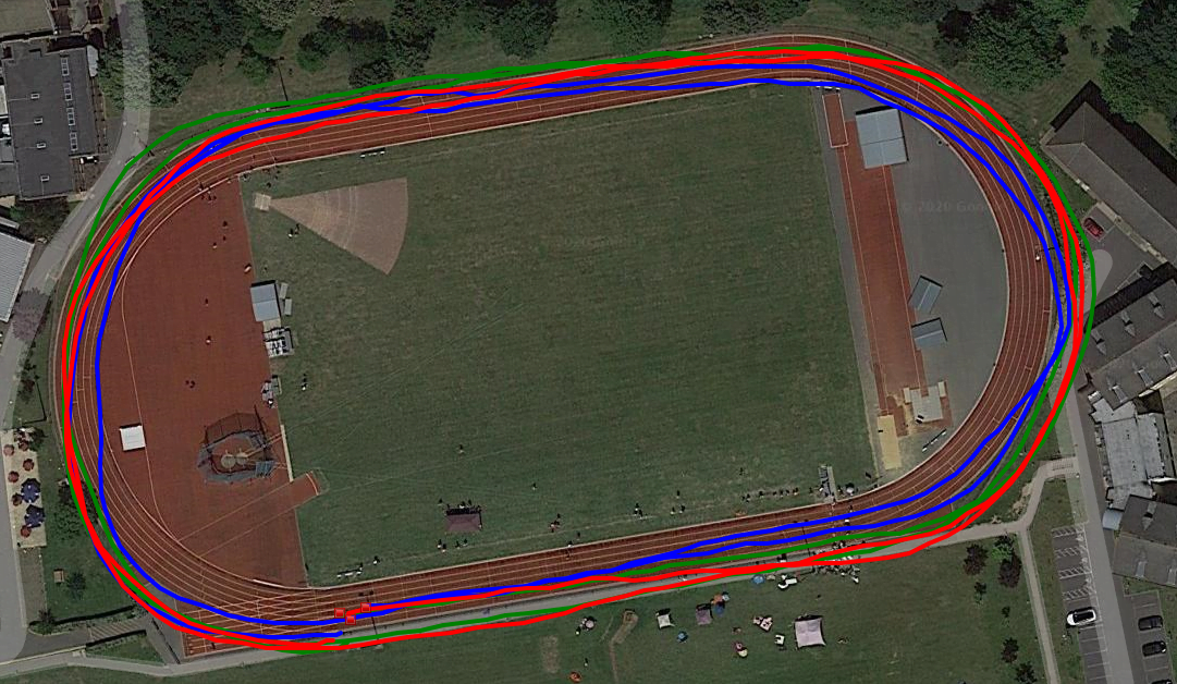
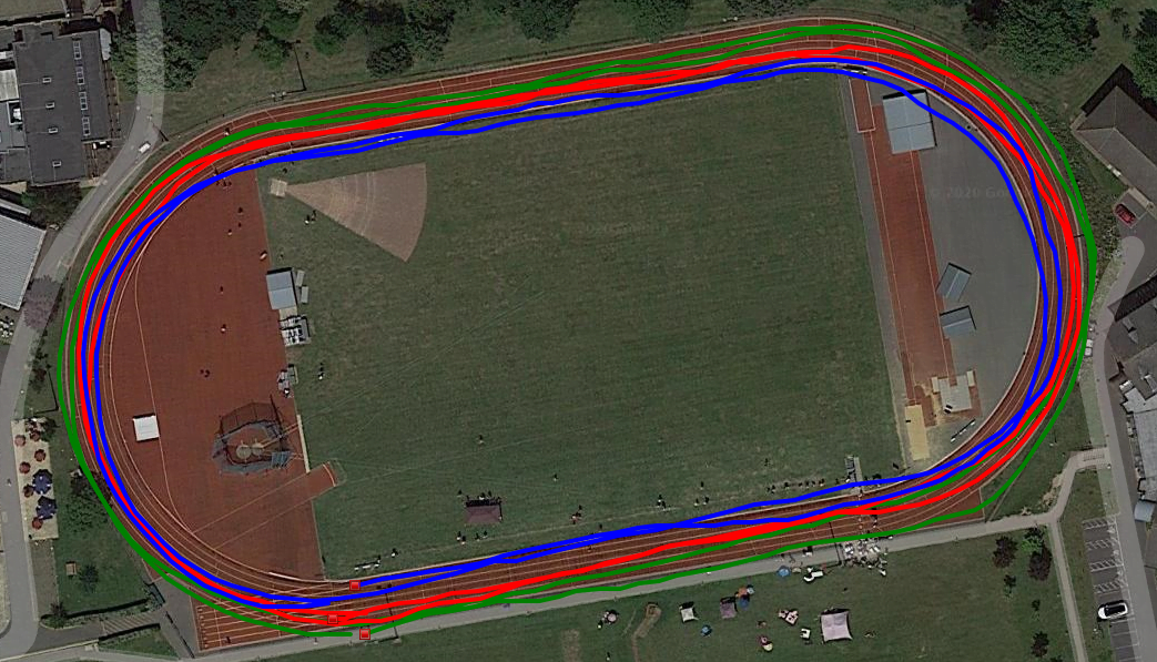
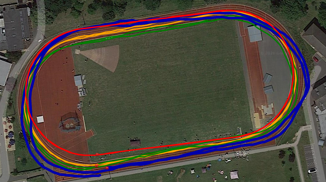
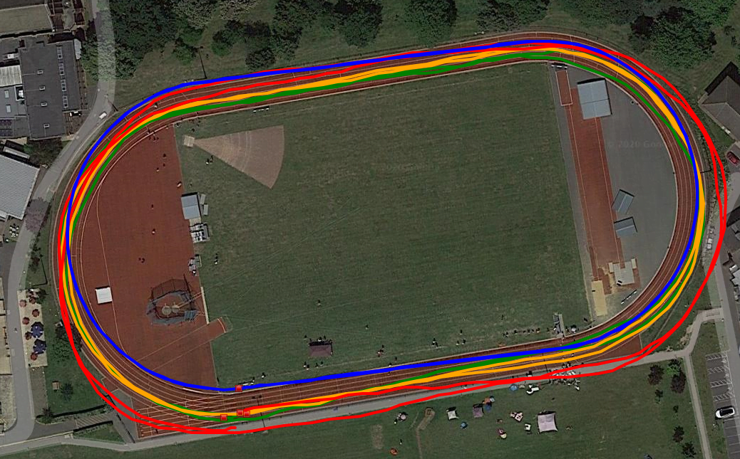
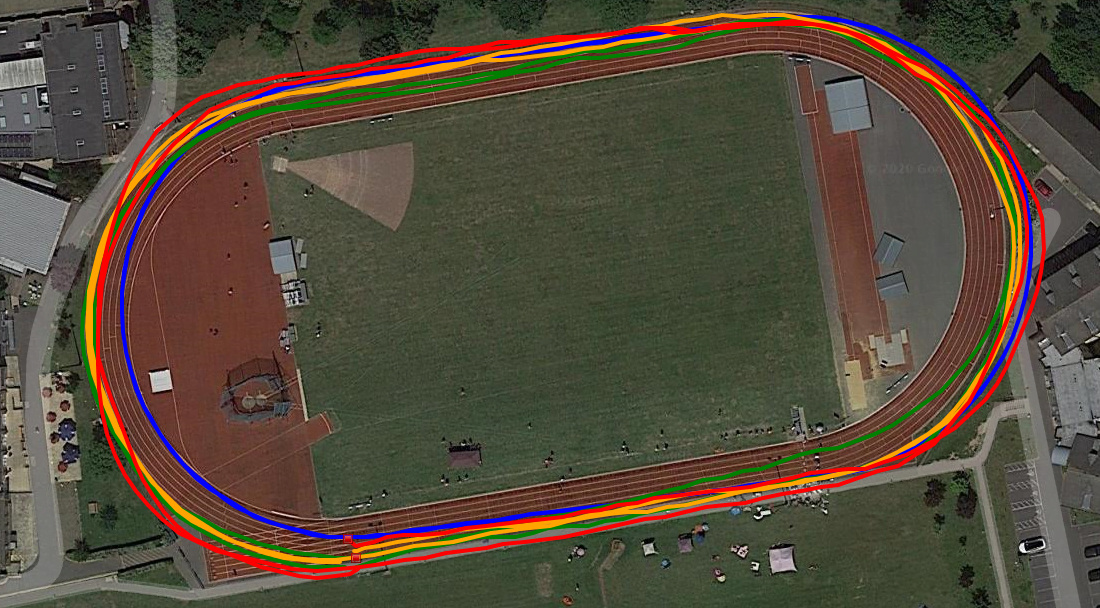
Let’s look at the 3 runs for each watch which should be 3 concentric ovals patterns.
Here’s the Vantage V…meh. I’ve seen worse.
Here’s the Garmin 945…less meh and you’d probably accept that.
Here’s the Coros Pace 2 (remember this test doesn’t favour Coros). Those are nice ovals but rotated slightly and moved to the right.
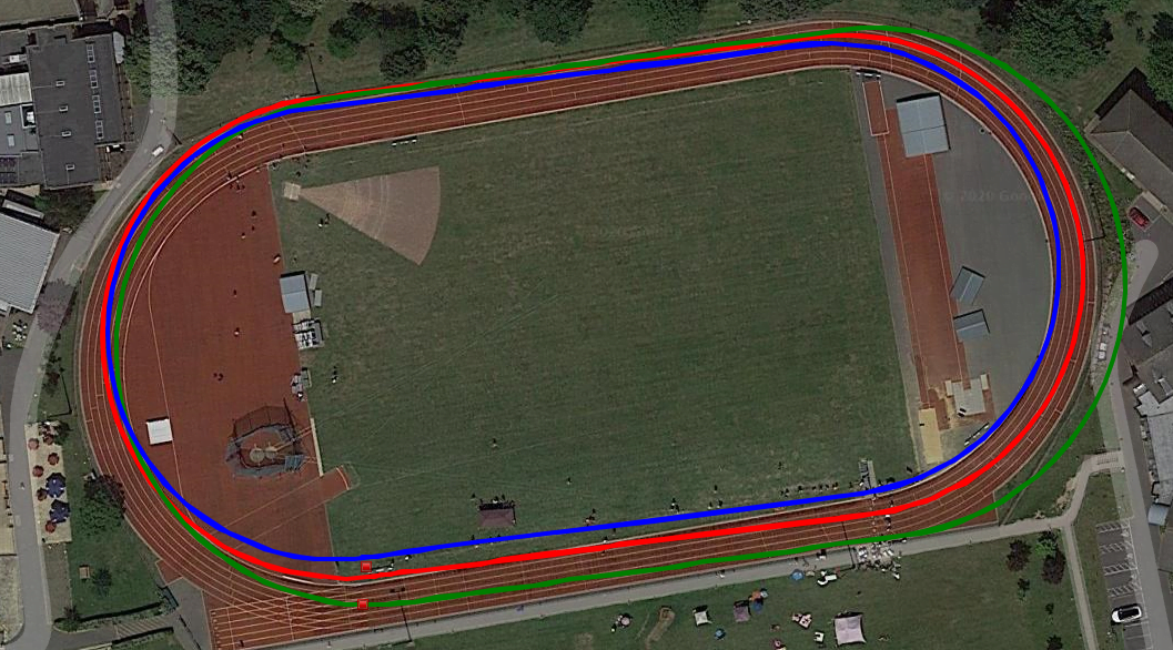
And here we have the 3 concentric(ish), calibrated ovals of the 745…nice. It’s clearly the best.

Ok, let’s slice and dice the data a different way and instead look at how each device performed on each 2 lap test with the data rounded to the nearest 10m
Lane 2 – actual 814m
- Polar Vantage V – 870m
- Garmin 945 – 820m
- Coros Pace 2 – 810m
- Garmin 745 – 830m
Lane 4 – actual 844m
- Polar Vantage V – 900m
- Garmin 945 – 860m
- Coros Pace 2 – 840m
- Garmin 745 – 850m
Lane 6 – actual 878m
- Polar Vantage V – 910m
- Garmin 945 – 880m
- Coros Pace 2 – 870m
- Garmin 745 – 890m
New Connect Functionality
This then brought me back full circle to something that @JohnK alerted me to, which neither of us had seen until recently. Garmin Connect (mobile) now colours your running track based on pace, heart rate or elevation. This just seemed to tell me that I did 2 fast (red) laps…but they weren’t fast, although they were consistent and that’s maybe why Garmin shades them like this in this particular instance, John’s image shows up the colours a bit more nicely.


Take Out
The Garmin 745 performs quite well here with a nice track and I can only assume that when the same feature arrives on the FR945 and F6 then there should be a similar level of performance. I’m not quite sure why the distances weren’t spot-on as the lane lengths are known.
The test was unfair on the Coros Pace 2, which would perform better over a single long track session.
Garmin didn’t specify lane distance when the lane was chosen, which needs to be changed to how Coros do it.
Both the Coros Pace 2 and FR745 *DO* allow you to specify a lane change mid-workout but I didn’t test that.
One other downside with the Garmin 745 was that NO LAPS were automatically shown as I had the autolap set to the default of 1600m (and each mini-workout was half that)
Return to Garmin 745 Review
Reader-Powered Content
 This content is not sponsored. It’s mostly me behind the labour of love which is this site and I appreciate everyone who follows, subscribes or Buys Me A Coffee ❤️ Alternatively please buy the reviewed product from my partners. Thank you! FTC: Affiliate Disclosure: Links pay commission. As an Amazon Associate, I earn from qualifying purchases.
![]()
Distance Linked Track Mode + Lap Button
I have not found detailed information on how the Coros or Garmin track modes operate, but I have a few ideas. First, your initial laps allow the system to “build” a track using standard track geometry. Second, the system utilizes your position in the world and a known database of tracks (which can improve over time). Third, the system uses satellite imagery to locate the track and translates your track to that imagery. A fourth option would be a combination of any or all of those above.
In considering these options, it’s very important to note that all track are not of equal geometry and satellite imagery has flaws. Track geometry will effect the measurements that the GNSS makes and the system’s translation. This is why, as you correctly state, that the system must allow the runner to input the track distance (400m/440yd or some other variation). Also, since the imagery satellites do not take their pictures directly above tracks and utilize large aperture lenses, there will always be some parallax in the picture. Therefore, a perfectly represented run may not align with the track. The Coros example in your article looks like this may be the case. I’ve seen similar results in other articles on the Coros. For the general public this will be frustrating. So, the option of aligning the run to an image may be preferred for marketing – NOT reality – purposes.
Regardless, most runners want the GNSS track mode function to work like the stopwatch and record 400m as 400m. That’s the trick though. No matter how good the run looks on satellite imagery, the GNSS has to get the start/finish line correct on the track – where our coaches hit the lap button, ignore the distance it thinks we ran and apply 400m exactly (or 440yds or some other distance that’s appropriate – think your favorite training loop with a known distance). With the stated accuracies of each system and other impactful factors: buildings, cloud cover, choice of GNSS, trees, differing track geometries, etc, defining and applying the start/finish line will not be possible for the current systems and hitting the lap button will be the only solution. Given these track modes (assuming we can enter a track distance) and the lap button, we’ll get a pretty plot, accurate distance and correct timing.
A quick note on your methodology: The choice to not use the same GNSS for each watch is puzzling. Although both of the “track” options obviously translate the GNSS position to specified position on the physical track, the starting point of that translation is impacted by the GNSS position. For a true test of ability/accuracy you should control the variables as much as possible. The choice of GNSS was a controllable variable. Given that you were not in a very high latitude and GPS II is available on all watches, the use of GPS alone on all watches would have been preferred for a true test.
GPS 3m
GLONASS 4m
Galileo <3m?
thank Erik for the detailed response. much appreciated. i’ll answer your points as best i can
– track location/geometry…yes it’s fun to speculate. it’s possibly a combination of those you say. IIRC the garmin one looks for parallel lines but Coros do something clever with the curves.
– 400m – yes i stupidly had autolap set to 1600 and not 400. #sigh.
– methodology, yes you are correct with the gnss stuff. this wasn’t ‘proper’ test as for that i would have run more and prepared better 😉 it was meant to be indicative, i know i wrote it up a bit formally (aka quickly) and yes i would have used gps-only tho perhaps not for the reasons you imply.
A bit unrelated, but is that track open to the public? I’ve recently moved nearby and thought it was closed to students only.
you can book it. i think it might have been closed a couple of weeks back.
I guess this makes Strava track CR’s pointless. I noticed slow runners with fast times. Just put it in track mode and cut the corners and upload to Strava. Oh well!
maybe, idk
but i believe that strava doens’t necessarily take your time+gps on trust and apply their own corrections. not sure if they do that at all on a track